Tuesday, December 25, 2007

Mexico, Huasteca, San Luis Potosi – December 16 to 23


Micos Put-in


Looking for sunshine in the wet and cold winter months? Want to paddle some warm water and run fun waterfalls? Check out some Mexican culture far away from tourists? Enjoy great hospitality and authentic Mexican food? Don’t want to worry about shuttling logistics or about convincing an airline attendant to check in your boat as skis? Make your way to the Huasteca region in San Luis Potosi and let Leland and Andria of Brushy Mountain Publishing and the Huasteca Secreta (HS) staff take care of the details! This was our first all-arranged paddling trip and it has set rather high standards and expectations for future ones.


Huasteca Secreta at Salto El Meco


Our Room with a View


USV - The Ultimate Shuttle Vehicle

To my great disappointment I was not able to paddle due to a shoulder injury, but the culture tour Juan and Jimena from HS arranged especially for me made up for it. Lucky Pete got to eat the cake and keep it too… He paddled all the rivers and joined me for artsy explorations.

Day 1 - Ojo Frio
I didn’t paddle, but according to Pete this is a very fun run with tons (about one hundred as Pete said) of ledges, small falls and boofs. It’s in the middle of sugar cane fields and very small Mexican villages. The Ojo Frois is actually a tributary of the Rio Gallinas (see Tamul Falls, day 4).


Day 2 - Micos Section of Rio Valles
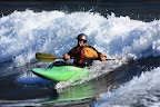
200+ ft/mile run consisting of the 7 super fun waterfalls. Beautiful drops over travertine rock terraces. Waterfalls as paddler-friendly as they can get: simple approaches and big and calm landing pools. Best of all, there was some action for me, too! The falls can be jumped and the pools swum. Lucky coincidence: just as our group put in, a local family jumped of the first falls, among them, two girls aged 10 or 12. I found the practical demonstration much more convincing than Juani’s and Leland’s assurance that this is a common local activity. Juani displays great paddling skills – this is his third river run ever. Or is it a sign how friendly the falls are? At the takeout, every paddlers dream: the bar is set up, dinner served right at the take-out and the HS staff loads up all the boats!


Falls #1: Leland showing how its done and Claudia taking a good look


Doing it without a kayak


Andria running #2


Juani sliding #3


Pete on #4


Matt running the tallest #5


Group below #6


Day 3 - Culture Tour
Pete and I are off on a culture tour with Jimena and Jorge, our driver. First stop were the newly excavated ruins of Tamtoc. No big pyramids like the ones in the Yucatan. But a number of nice sculptures, the largest calendar stone (depicting a ritual sacrifice that took place every 53 years) and a statue of the chief – foot to waist – in the buff.

The calendar stone

After driving another hour or so, we end up on a side road high in the limestone mountains. Jimena finds a little boy who leads us up through the forest to a 60 meter wide gaping hole of Sótano de las Huahuas, a 200 meter deep limestone pit cave. After the sun sets, birds (actually not swallows but swifts) start circling directly above us and make their kamikaze dive to their sleeping places deep in the cave. We sit directly under the flyway of tens of thousands of birds that rush by in waves with great noise and whooshing of their wings. The amazing spectacle lasts for about half an hour until dark. For unknown reason we left our headlamps in the car, but make good progress in the moonlight and with Jimena’s little keychain light.

Sótano de las Huahuas

We drive on to Xilitla our final destination of the day. During dinner at open windows we watch bustling night life in the town square. Here we also see a family of three Gringo tourists – the only ones we saw on this trip (except us).

Day 4 - Culture Tour continued
Before breakfast we go for a little stroll through Xilitla. It’s perched on top of a limestone ridge and makes the impression of an authentic Mexican city: narrow busy streets with merchants opening their stores, rows of colorful houses, shouting newspaper boys, laundry flapping in the wind, flowers and noisy birds.


On to the next cultural point: Las Pozas, the surrealistic architectural garden in the semi-tropical rainforest by Sir Edward James. James was a British patron of surrealistic artists and rather surrealist himself. We take an hour to wander through the enchanted forest and discover new fantastical creations around every corner.


For lunch we reunite with the others in the largest city of the area Cd. Valles. One of the river runners experienced unfortunate back problems on yesterdays El Salto run necessitating a hospital visit to check out the problem. But he rejoins us for our trip to the HS resort at Tamul falls. Here Rio Gallinas drops over hundred meters into the Santa Maria (which is called Tampaon further downstream). Everywhere one looks from the HS bungalow high on the ridge no signs of human activities, untouched forested mountains, and deep below the majestic falls. Sitting on the terrace with a Corona in hand and watching the falls darken in the disappearing sunlight we are probably the only witnesses to this spectacle.


Day 5 - Back to the Micos
More dropping and jumping of waterfalls. A funny episode: three paddlers show up with first generation playboats (RPM, Supersport). The somewhat nervous woman boater asks her trip leader how to run the falls: “Just paddle over the falls and lean back.”, he replies. After watching our group running the falls, she turns to him and said, “But they’re all leaning forward!?” The leader replies, “Hmmph, you will have to ask Leland about that”, and of he goes, penciling in old-school-style with arms and paddle high over his head. Bar and snacks at the take-out. Fantastic dinner at a terrace at the lip of the Salto des Mecos falls above the resort.


Matt, Lisa, John, Juani, Ricardo, Kemper and Karen styling Micos #4


Day 6 – El Salto section of Rio Valles
The group paddles the El Salto for the second time, Pete’s first run. He reports three more exciting drops: El Nemo, a smaller one that ends in a mandatory boof over a hole, La Luminosa, and El Salto. The most scenic drop is the Aquarium.


Andria and Leland at El Nemo


Dooley showing us how to fly a canoe


Kemper taking a look at the Aquarium

Not being able to follow the group on the river, I join Juani senior, Juani junior and Jimena checking out the (dry) falls just upstream of the put-in. We run into a wedding photo shoot and the falls begin to flow! Nice surprise. I also get some good shots of Juani and Jimena jumping of a cliff – higher than any of the Micos drops and into totally green water. The good-bye dinner takes place at the HS beach – excellent food as every evening surrounded by candles and with music all night.

A few general observations:
Food is just amazing - don’t expect to loose weight. Be prepared to be waited on hand and foot (although this may change once HS are in regular operation). Huasteca roads are bad and driving takes for ever, come with patience. If you are on your own, a basic knowledge of Spanish is necessary to travel in this area.

Thursday, October 18, 2007

Larches and Snow in Manning Park, October 14


Did a day trip up Frosty Mtn. (2406m). It’s a 7 hrs round trip; half of the trail was on snow already. After 7 or 8 km one gets into open larch groves. Larch needles change into a vibrant yellow before they drop in fall. Larches are the only trees that can grow at this elevation, but very slowly only.


A tree with a trunk of 40 cm diameter may be 2000 years old – supposedly the oldest trees in BC. They are more common in the Rockies; Manning Park is the western end of their range.


From the summit excellent views of countless snow-covered pointy Cascade peaks.

Thursday, October 11, 2007

Fraser Canyon Revisited, October 6 - 8

We escaped the wetcoast for a fill of sun on Thanksgiving weekend and explored the area around Big Bar ferry on the Fraser. From Lillooet we took West Pavilion FSR north, crossed the river at Big Bar ferry and did some mountain biking and hiking further north. First we scrambled down to Big Eddy, our last campsite on the Fraser trip, and recovered Pete’s glasses, then hiked on a bench along Moran Canyon to Kelly Creek with abandoned mine works. After crossing the Fraser we drove up a rough and excitingly steep gravel road to Jesmond Fire Lookout at 1970 meter. This is the northern end of Marble Range Provincial Park. Great views of the Fraser Canyon to the west and the flat lake country to the east. But freezing cold up there and hail showers. Last but not least we made our way into the Cathedrals, a wall of Bryce-Canyon-like pinnacles we had discovered on our river trip two weeks ago. The Cathedrals are on the east side of the Fraser between China Gulch and Deadmen Creek. Excellent easy riding through dry Douglas fir forest and open rangeland towards the Fraser and then hiking along bunch grass benches, across a couple of canyons, slides and ravines, a 9 hr roundtrip. Astonishing scenery. Endless vistas of canyons, cliffs and hoodoos, resembling the canyons in southern Utah. And not another human being anywhere.

Moran Canyon of the Fraser


Waiting for the Ferry


Fall Aspen


Bighorn Sheep


View from Jesmond Fire LO to Big Bar Creek and Fraser Canyon


Morning Frost


Riding on the Benches


Colliseum


Fraser Cathedrals


Cathedrals


Grassy Benches above the Fraser


Fraser and Churn Creek Protected Area

Monday, September 24, 2007

Chilko, Chilcotin, Fraser - September 16-23

SUMMARY

From Chilko Lake to Lillooet by river. Not the fastest way, but shorter than by road and surely more scenic! The 330 km or so took us 8 days.

Breathtaking scenery from Chilko Lake’s glacier-capped mountains and evergreen forests past the hoodoos of Farwell Canyon to the pinnacles, towering cliffs and narrow dark canyons of the Fraser. We traveled on the clear green Chilko until the Taseko mixed the waters up into a light milky green for the ride on the Chilcotin, all to be swallowed by the muddy tan of the Fraser.

The Fraser is British Columbia’s largest river and its main stem is still running free. The reaches we explored are surprisingly remote and untouched. Many stretches along the rivers are protected as BC parks: Ts’y-los, Bull Canyon, Junction Sheep Range, Churn Creek Protected Area, Edge Hills.

Although most of the kayaking was a scenic float, we had three days with excellent whitewater action. These happened on day 2 with Chilko’s famous Bidwell, White Mile, Eagle’s Claw and Lava Canyon, day 4 with Farwell and Big John Canyons of the Chilcotin and day 8 with whirlpools and gigantic waves on the Mighty Fraser. Yup, even if it looks mostly flat in the pictures there was actually some good whitewater. But with a raft to keep in front of and up to 60 km to paddle each day there was no time for setting up for shots. Heck, not even for scouting – the only rapids we looked at were Bidwell, Farwell (on the shuttle 4 days before we ran it) and French Bar – scouting the last turned out to be unnecessary.


Along the way was plenty of wildlife to observe: a very inquisitive grizz cub, an athletic black bear, jumping red-sided salmon, cliff-dancing sheep and the ubiquitous eagle.


After day 2 we encountered only one other human being (the chief ferry man at Big Bar – this is bar as in sand bar… not booze bar), but there were plenty of signs of human activities: from native petroglyphs and fishing structures over thundering rapids to abandoned mine sites glued like swallow nests to sheer cliffs in inaccessible places.


Check out our route, campsites and some of the rapids on BC OpenMaps


A few more numbers:
Chilko: 60 km, 60 cms, 5 m/km (Bidwell section 8 m/km)
Chilcotin: 125 km, 120 cms, 3 m/km
Fraser: 140 km, 1200 cms, 1.8 m/km
Total elevation drop: 976 m


TRIP REPORT

Day 1: Chilko Lake to Mid Chilko, 20 km – 3 hrs
Sokeye are jumping and a grizz cub is staring at us in wonder as we float by. Lots of flat water. The night gets really cold – no wonder this is fall in the Chilcotin.

Chilko Lake


Sorry, just had to put this one in - most salmon were still quite alive


Day 2: Mid Chilko to Taseko Junction, 40 km – 5 hrs
Excellent whitewater. Some class III in s-bends upstream of the kayaker put-in. John hits the kayaker last-chance eddy above Bidwell (in his 16 ft raft). Bidwell feels bigger than it looked from shore. White Kilometer and White Mile are great fun roller coaster rides. Read and run through Eagle’s Claw. A black bear in the narrow lava canyon below sends John and the raft on collision course with the opposite canyon wall.

Bidwell (at 60 cms) - note the wood on bottom left


Check out some exciting action images of Bidwell on the Northwest Brigade Paddling Club blog.

Entrance of Bidwell
Below Bidwell

Running Bidwell - photo Matt Feagan


Taseko Junction


Day 3: Taseko Junction to Dee’s Corner, 55 km – 6.5 hrs
The milky Taseko joins the clear Chilko creating the typical light blue color of the Chilcotin. Nice class II to Siwash Bridge, which poses no problem at this low water level. Later lots of flat water. Somewhere the small Chilcotin mixes its waters with Taseko and Chilko and the river takes its name. Entertainment is provided by a bear swimming across the river in front of us and climbing a near vertical cliff, sending gravel flying into the water. Good scenery but no whitewater through Bulls Canyon. Some agriculture and roads close to the river until we get to the start of Hanceville Canyon.

Cold Foggy Morning


Day 4: Dee’s Corner to Big Creek, 40 km – 5 hrs
Great scenery in Hanceville and Big Creek Canyons and entertaining whitewater, class II-III. We are definitely getting into sagebrush country now. Camp at confluence with Big Creek – nice spot. Good hike through open pine and Douglas fir forest onto a ridge with lots of curly grass (bunch grass).

Big Creek Canyon


Day 5: Big Creek to Fraser River/McEven Creek, 40 km – 5 hrs
More great scenery and some class II-III until we get to Farwell Canyon, about IV- at this level. Easily scouted from the bridge: a couple of offset holes above and a squirly narrow canyon below. Junction Sheep Range Park is now on our left, with semi-desert cliffs, hoodoos, but we don’t see a single member of the largest bighorn sheep herd in BC. Big John is the most impressive canyon on the Chilcotin and provides a fun 2 km class III roller coaster ride through a narrow gap between steep cliffs. A couple of kilometers downstream the glacial blue flows of Chilcotin are swallowed by the brown sediment loaded water of the Mighty Fraser. Hoodoos, cliffs, and thankfully fast current. The rapids marked on the canoe guide are nothing but short wave trains.

Chilcotin Hoodoos


Farwell Canyon


Start of Big John Canyon


John in Big John Canyon


Fraser Chilcotin Confluence


Day 6: McEven Creek – Deadmen Creek; 50 km – 5.5 hrs
Soon we float by Gang Ranch Bridge. On our right is Churn Creek Protected Area. All flat water today, but moving at a good click of 10 km/h past a spectacular scenery; an endless parade of hoodoos, steep canyon walls, pastel-colored cliffs. A couple of outstanding landmarks: the “Pulpit” above Lone Cabin Creek and the “Cathedrals” between China Gulch and Deadmen Creek. The latter are a 2 or 3-kilometer wall of pinnacles reminiscent of Bryce Canyon. Camped on sandy beach. Checked out abandoned gold mine above our campsite and hike to the pinnacles for a closer look.

Fraser Cathedrals


Beach Camp


Day 7: Deadmen Creek to Big Eddy, 51 km – 6 hrs
Some whitewater today, albeit French Bar Rapid comes only in at about class III. It’s not typical of the Fraser rapids downstream. The river does not narrow, it just gets shallow. Hey Diddle Diddle, right down the middle ... is the best bet although John decides to explore a few big waves (reversals) on the bottom right. Around the corner are a few whirlpools and waves (one of them a stellar surf wave Pete checks out) and a constriction with some more swirly water. 3 km below French Bar is the Big Bar ferry crossing, where we stop for a chat with the ferryman. We float by the hoodoos of Watson Bar, through Chisholm Canyon and another Canyon above Begby Creek. In many impossible places old roads come down to the river, most of them obliterated by slides or floods, witnessing the miner’s industrious activities. The plan is to camp somewhere below Leon Creek, but I guess I didn’t look close enough at the map. The river narrows and enters Moran Canyon which continues for about 10 km without flat spots for tents. Nothing at Kelly Creek, a major side canyon, only a couple of mining shacks glued to the cliffs. Where the map shows a big eddy we find finally a good spot, but have to do some rockwork to clear the campsites.

It was here in 1808 that Simon Fraser and his men had to abandon their canoes and continue their journey to the Pacific on foot. Moran Canyon was also the site of a proposed hydroelectric dam in the 1950’s and 1970’s. The dam would have turned the river into a lake, reaching 260 km upstream to Quesnel. Alas, the dam was never built and the main stem of the Fraser is still the largest river in the North American Pacific (and possibly one of the world’s largest rivers) still running free of human alterations.

Above French Bar


Chisholm Canyon


Still Searching for a Flat Spot for our Tents


Old Mine at Kelly Creek - no camping here


Moon and Whirlpools - finally found a spot


Day 8: Big Eddy to Takeout, 25 km – 3 hrs
The description in an old canoe guidebook warns against entering the lower canyons – “Moran Canyon … can only be run with moderate safety by inflatable rafts of 20 feet length…” But this section is commercially rafted – so how bad could it be? So we run ‘Pipeline’ – a big curling crashing wave, ‘Powerline’ – a wave train followed by a swirly squeeze, ‘Split Rock’ and even find a new (well, at least unexpected) rapid – ‘Surprise’, with a massive (but avoidable) wave train, a narrow squeeze between huge boulders and big whirlpools and boils. We pass through a couple more scenic canyons: Pavilion and Fountain and we are at the take-out. The black polished boulders on shore look as if we are in the deep dark guts of the river. And indeed, we are: when I had a look at the take-out in July, 10 or 15 meters of water were above the very spot where we stepped on shore.

Never-ending Canyons: Moran, Pavilion, Fountain